Plus The map is included with Plus and Pro

Pharmacy and GP map The whole local market,
on one map.

Pick any place in the UK and see every pharmacy, GP practice and care home around it, who lives there, where their prescriptions go, what has changed and where a pharmacy's items would go if it closed.

  • England, Scotland, Wales and Northern Ireland
  • Circles from 1 to 20 km
  • Official NHS and regulator data

MapVictoria Park Health Centre, LE2 1XD3 km

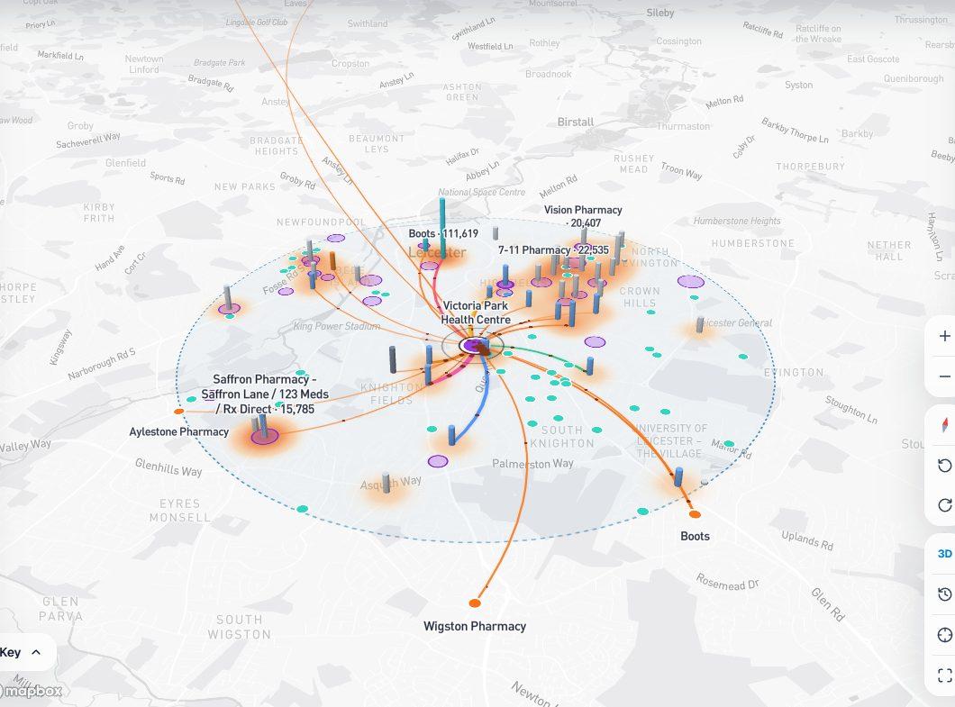
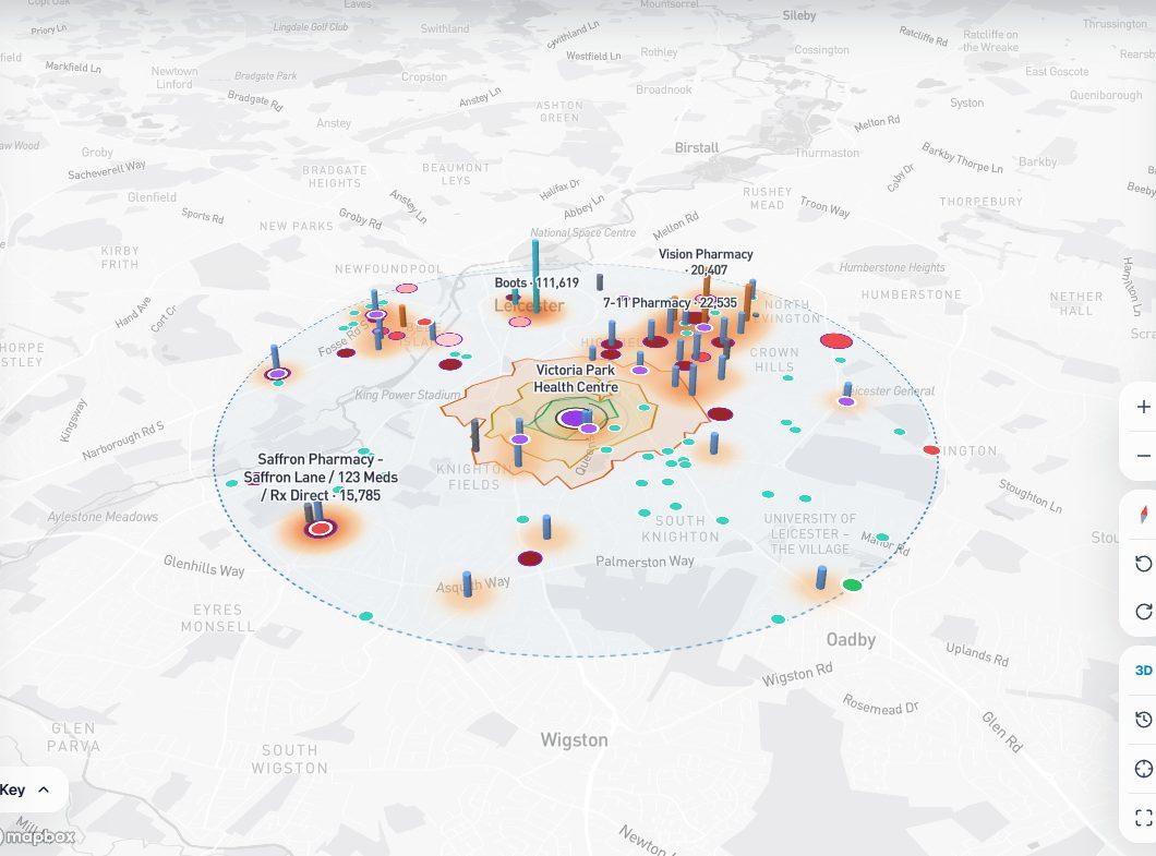
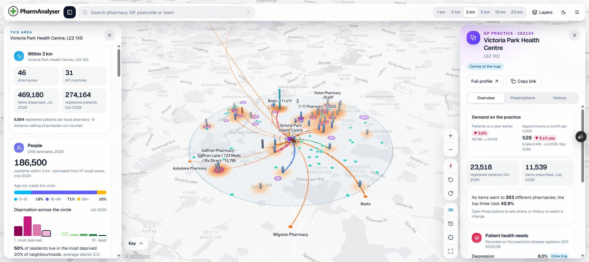
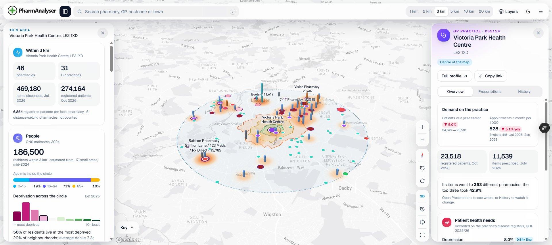
The map around Victoria Park Health Centre in Leicester: lines run from the practice to the pharmacies that dispensed its prescriptions, with the area panel on the left and the practice's card on the right.
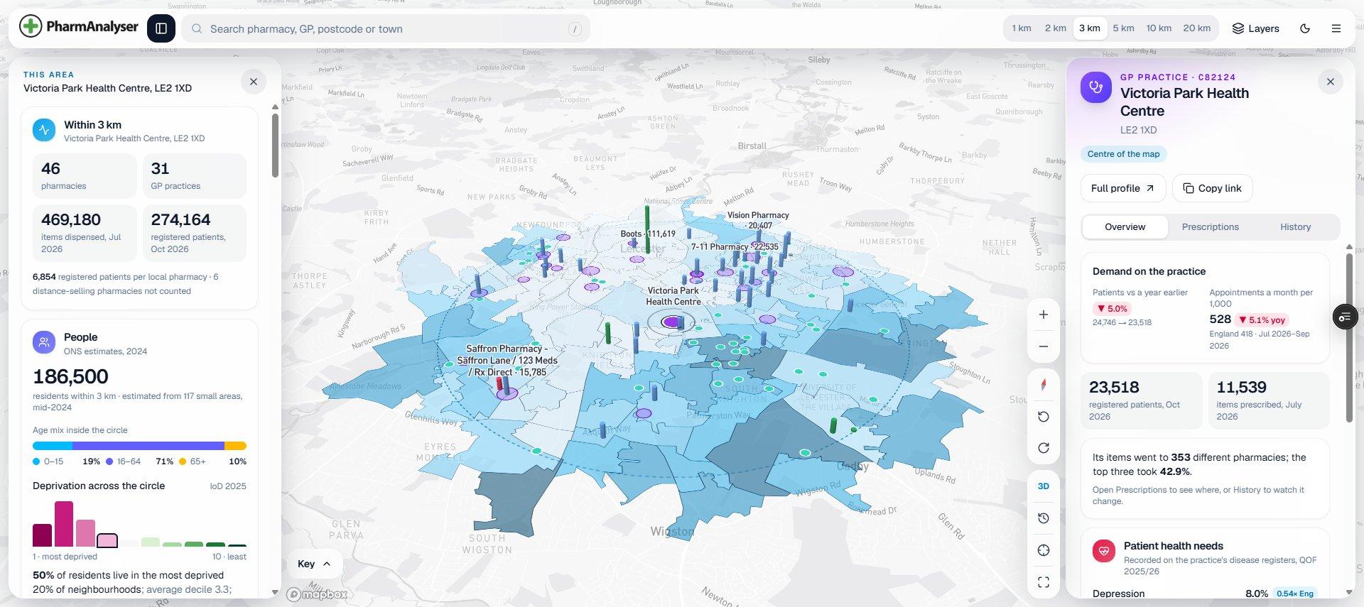
The same view with pharmacies coloured green, blue or red by nomination momentum and small areas shaded by the share of residents aged 65 and over.
The same view with GP practices coloured by appointments per 1,000 patients, the walking zones from the centre and markers for recent changes.

Prescription flows. Where Victoria Park Health Centre's prescriptions were dispensed, pharmacies coloured by owner and raised by items

EPS nominations. Pharmacies coloured by EPS nominations against 13 weeks earlier, small areas shaded by residents aged 65+

GP demand. GP practices coloured by appointments per 1,000 patients against England, walking zones from the centre, and recent openings, closures and changes of owner

pharmacies within 3 km, six of them online
46
GP practices with 274,164 registered patients
31
residents, from 117 small areas (mid-2024)
186,500
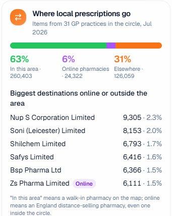
of the practices' items dispensed in the area, July 2026
63%

The example above: 3 km around Victoria Park Health Centre, LE2 1XD, Leicester.

On the map

Everything about a place, in one view.

Draw a circle anywhere. The map shows what is in it, and the panels add it up for you.

  • Every pharmacy and GP practice

    Around any place, address, postcode, pharmacy or practice: coloured by owner, raised by items dispensed, with a heat map of supply.

  • Who lives there

    Residents and age mix in the circle, and every small area shaded by deprivation or the share aged 65 and over.

  • Where prescriptions go

    Lines from a GP practice to the pharmacies that dispense its items, or into a pharmacy from the practices that feed it.

  • Walking access

    10-minute walking zones around every walk-in pharmacy, and how many residents live beyond them.

  • Who is gaining

    EPS nominations now against 13 weeks earlier, and each pharmacy's share among its neighbours within 1.6 km.

  • Demand on GP practices

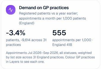
    Patient list growth on a year earlier, and appointments a month per 1,000 patients against England.

  • What changed

    Openings, closures, changes of owner and moves, and a time-lapse of monthly items for every pharmacy in view.

  • Care homes

    Every registered care home in the circle with its provider, service and nearest walk-in pharmacies.

  • If a pharmacy closed

    Where its prescription items would most likely go within 5, 10 or 20 km, from where its prescribers already send their other items.

  • Your Watchlist

    Your own sites and the competitors you watch, pinned on the map, with openings, closures, changes of owner and moves near your sites. Watchlist is on Pro.

  • Scotland neighbourhoods

    Draw the neighbourhood for a new pharmacy application: residents, deprivation, walking access before and after the premises, public transport and past committee decisions.

  • Reports to download

    The circle as a PDF area report, and a Scotland neighbourhood as an evidence pack, each figure with its period. On Pro.

The area

Read any area at a glance.

The area panel adds up the circle as soon as you draw it, and every card says which month it shows.

  • Pharmacies, GP practices, items and registered patients
  • Where the practices' prescriptions are dispensed: in the area, online or elsewhere
  • Patient growth and appointments per 1,000 against England
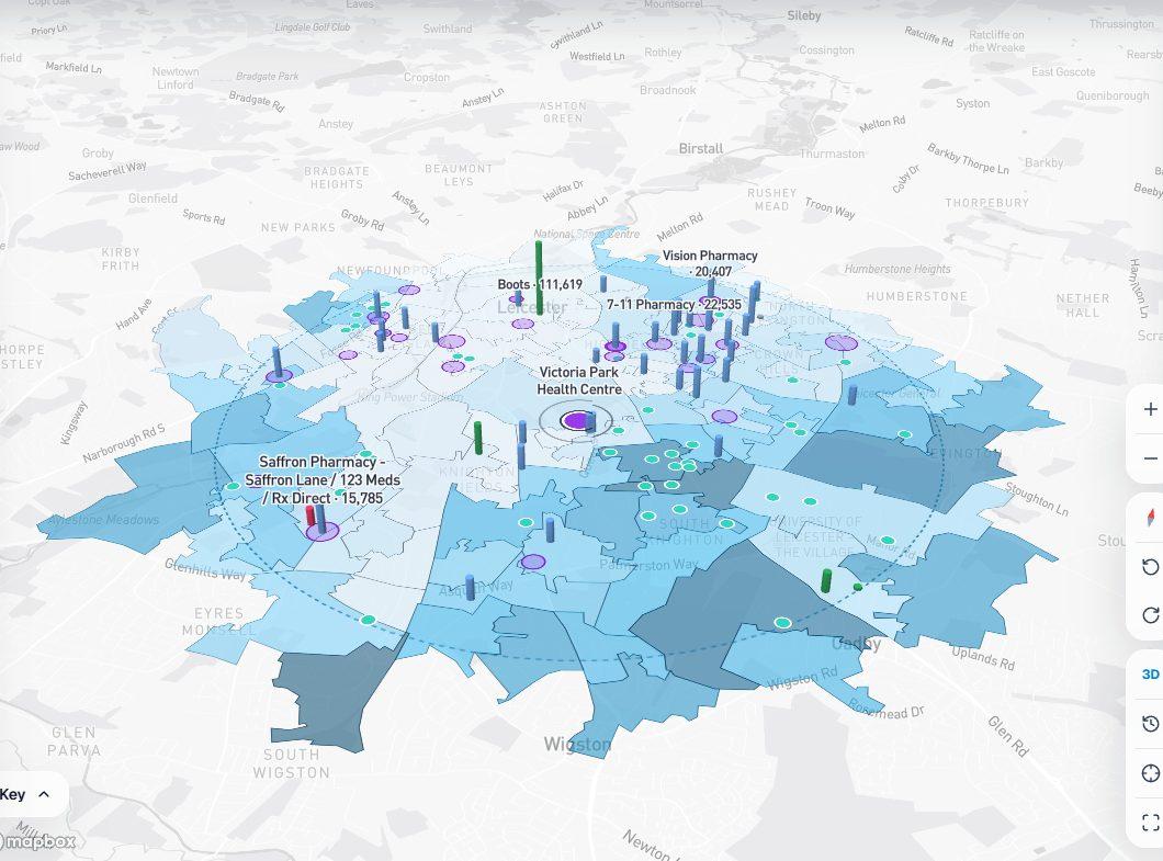
Small areas around Victoria Park Health Centre shaded by residents aged 65 and over.
Where local prescriptions go: 63% in this area, 6% online pharmacies, 31% elsewhere, with the biggest destinations.
Demand on GP practices: patients down 3.4% on a year earlier; 555 appointments a month per 1,000, England 418.
Pharmacies and practices

Open anything on the map.

Hover for the headline numbers. Click for the full card, without leaving the map.

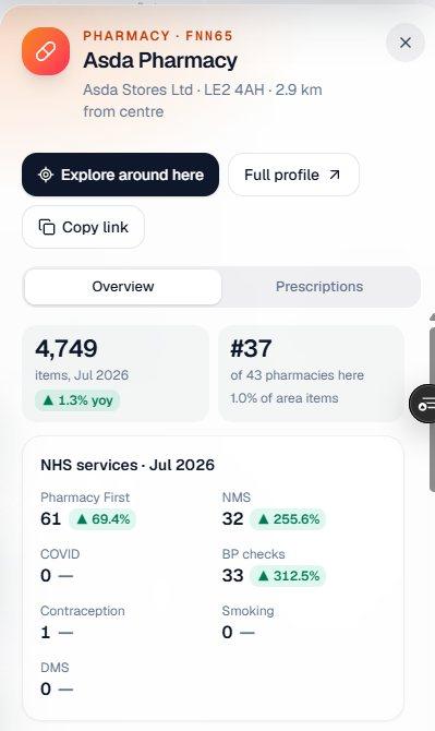
  • Items, rank in the area and NHS services for each pharmacy
  • EPS nominations and share among its neighbours
  • Owner history: changes of owner, openings, closures and moves
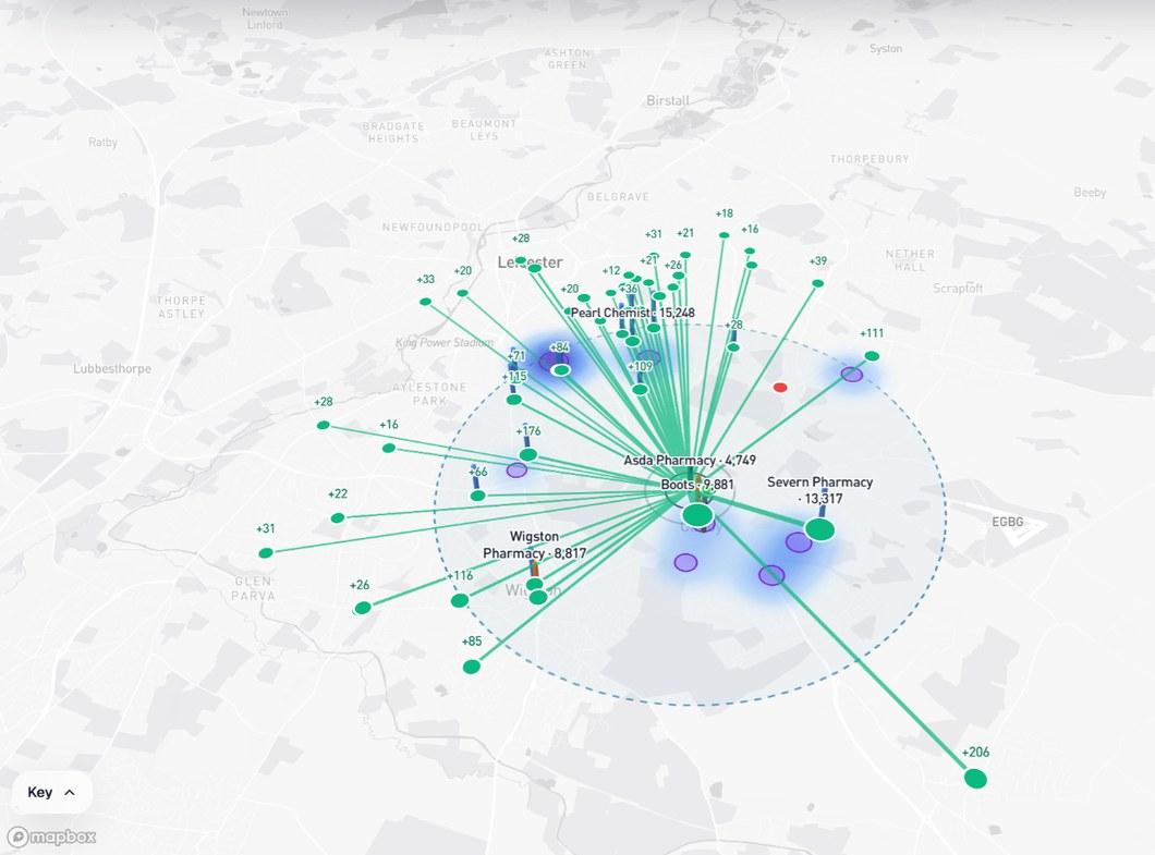
Prescription flows from Victoria Park Health Centre to the pharmacies that dispensed its items.
Asda Pharmacy's card: 4,749 items in July 2026, 37th of 43 pharmacies here, and its NHS services.
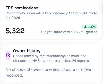
Asda Pharmacy's EPS nominations: 5,322, up 1.9%, +0.5 points share within 1.6 km, gaining.
Access and momentum

See who is gaining, and who is out of reach.

Spot the pharmacies winning patients, and the streets where a pharmacy is more than a short walk away.

  • Residents more than a 10-minute walk from a walk-in pharmacy
  • Pharmacies gaining or losing nominations against their neighbours
  • Openings, closures and changes of owner over the last two years
GP practices coloured by appointments per 1,000 patients, walking zones from the centre and recent changes.
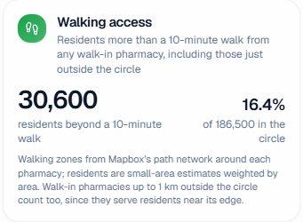
Walking access: 30,600 residents, 16.4% of 186,500 in the circle, are more than a 10-minute walk from a walk-in pharmacy.
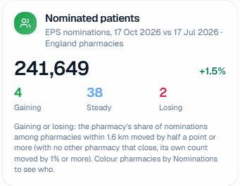
Nominated patients: 241,649, up 1.5%; 4 pharmacies gaining, 38 steady and 2 losing.
If a pharmacy closed

See where its patients would go.

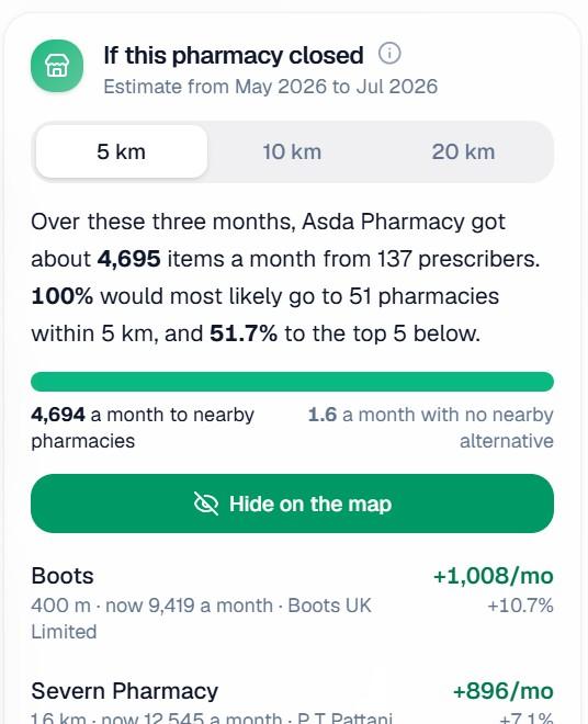
Open any pharmacy to see where its prescription items would most likely go if it closed, from where its prescribers already send their other items.

  • Within 5, 10 or 20 km, with what each nearby pharmacy would gain
  • Items with no nearby alternative, counted on their own
  • The whole circle as a PDF area report, on Pro
Green lines from Asda Pharmacy (LE2 4AH) in Leicester to the pharmacies that would most likely take its prescription items if it closed.
If this pharmacy closed: Asda Pharmacy got about 4,695 items a month from 137 prescribers; 100% would most likely go to 51 pharmacies within 5 km, and 51.7% to the top 5.
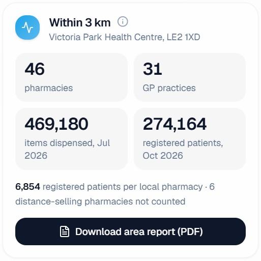
Within 3 km of Victoria Park Health Centre: 46 pharmacies, 31 GP practices, 469,180 items dispensed in July 2026 and 274,164 registered patients, with the Download area report (PDF) button.
Scotland neighbourhoods

Make the case for a new pharmacy.

Draw the neighbourhood for an application, and the map gathers the evidence a Pharmacy Practices Committee weighs.

  • Residents, ages and deprivation inside the boundary
  • Pharmacies, GP practices and care homes in and around it, and past committee decisions nearby
  • Walking access before and after the proposed premises, and public transport
  • Versions saved to your account; the evidence report as a PDF on Pro
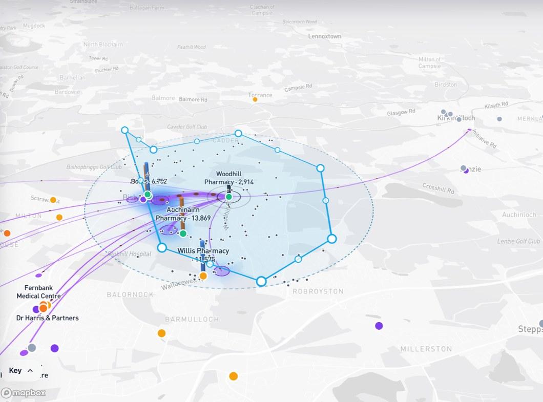
A neighbourhood drawn around Bishopbriggs, north of Glasgow, its boundary snapped to the roads.
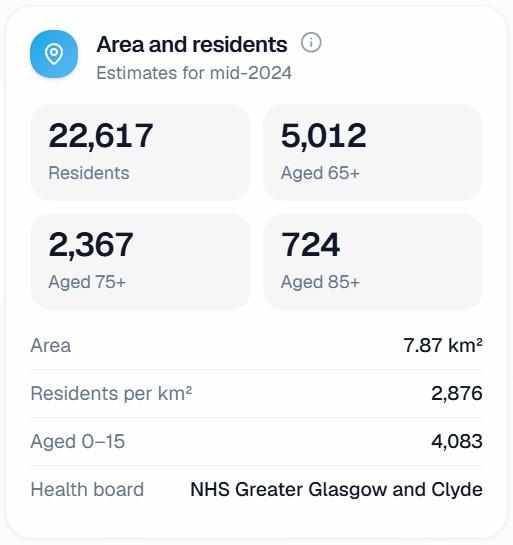
Area and residents: 22,617 residents, 5,012 aged 65 and over, 7.87 km², in NHS Greater Glasgow and Clyde.
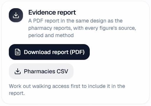
Evidence report: a PDF in the same design as the pharmacy reports, with every figure's source, period and method.
How it works

From a postcode to the full picture in three steps.

  1. 1

    Pick a place

    Search a pharmacy, GP practice, postcode, town or address, or drop a pin, and the map centres on it.

  2. 2

    Draw the circle

    Choose 1, 2, 3, 5, 10 or 20 km. Everything in the panels is worked out for that circle.

  3. 3

    Turn on what matters

    Switch layers on and off, then open any pharmacy, practice or care home for its detail.

Questions

About the map.

Anything else? Talk to us.

Which parts of the UK does it cover?

All four nations. Pharmacies, GP practices, care homes, residents, small-area deprivation and where local prescriptions go are shown in England, Scotland, Wales and Northern Ireland. Some layers follow what each nation publishes: EPS nominations and GP appointments are England only, and NHS services by pharmacy cover England and Scotland.

Where do the figures come from?

Official published NHS, population and regulator data, as each nation releases it. Each card says which month or week it shows.

Which plans include the map?

Plus and Pro, and Enterprise workspaces. On Pro you can also download area reports and Scotland neighbourhood evidence packs as PDFs, and see your Watchlist on the map. Searching and pharmacy and GP profiles with headline figures stay free.

Are the population figures exact?

They are estimates: residents of each small area, counted in proportion to how much of it lies inside the circle. Walking zones are worked out on the path network around each pharmacy.

See your area properly.

The map comes with Plus and Pro, with everything else in those plans.

Subscribe to Plus for £9.99/month and get Pro (£24.99/month) for your first month (30 days) at no extra cost. £9.99 is charged today, and it stays £9.99/month unless you choose to upgrade.